Extreme Ball Lightning - second story installment
FORTE satellite - its prior mission and present day importance
First Installment
The material presented in the first of three divisions of the original paper contains quotations from a report sent by one M. Fitzgerald, the observer of the described event, to the Royal Society. The event described by Mr. Fitzgerald reportedly took place on August 6, 1868, in County Donegal, Ireland. The authors of the following paper traveled to a geographical area in Ireland that was believed to match the description given by Mr. Fitzgerald in his report to the Royal Society. The area was examined for present day physical changes to the countryside that would lend credence to the Fitzgerald report made in 1868. (KC4COP)
EXTREME BALL LIGHTNING EVENT OF AUGUST 6, 1868 IN COUNTY DONEGAL, IRELAND
J. Pace VanDevender*, Aaron P. VanDevender†,
Peter Wilson¶, Peter van Doorn**,
and Niall McGinley††,
Introduction
Although laboratory experiments have produced glowing balls of light that fade in <1 s after external power is removed and theories have been proposed to explain low-energy events, energetic ball lightning is not understood. A seminal event that illuminates the fundamental nature of ball lightning is needed to advance our understanding of the phenomenon. In search of such an event, we have investigated the energetic ball lightning occurrence of August 6, 1868, in County Donegal, Ireland; it was reported to the Royal Society by M. Fitzgerald1. It lasted for 20 minutes, left a 6 m square hole and a 100 m long by 1.2 m deep trench, tore away a 25 m long and 1.5 m deep stream bank that diverted the course of the stream, and terminated by producing a shallow cave in the opposite bank of the stream. We found and characterized the site and show that the geomorphology and carbon dating support the account by M. Fitzgerald.
We find that the excavation is not consistent with chemical, nuclear, or electrostatic forces but is consistent with a 1-MHz source of magnetic induction expelling the moderately conductive, water saturated peat down to the underlying clay/rock layer. The reported small size of the ball-lightning core, the size of the depressions, the yield strength of the peat, and the lack of any mention of smoke or steam in Fitzgerald's report are consistent with a magnetically levitated mini black hole weighing more than 20,000 kg.
The results suggest that such energetic ball lightning should be detectable at great distances by its electromagnetic emissions, which might provide a characteristic signature to reveal the source of the energy and the equilibrium configuration of the contained currents. Unexplained intermittent emissions in the MHz range are necessary but not sufficient indicators of such emissions. We report on over fifty 1 to >1000-s bursts of electromagnetic energy between 3 MHz and 350 MHz that were recorded by the FORTE satellite in October of 1997 and that are not consistent with known sources. Ground-based time-resolved observations should help identify the origin of the FORTE emissions and may help find and understand modern energetic ball lightning events.
Original Report from 1868
One of the most energetic ball lightning events ever reported occurred on August 6, 1868, in County Donegal, Ireland, and was witnessed by Michael Fitzgerald, who dutifully reported it to the Royal Society in London. The original publication [1] in the Proceedings of the Royal Society describes a series of excavations in the peat by the ball lightning and is reproduced below since it is very difficult to get access to the original.
“On the 6th of Aug. 1868, this neighbourhood being free from the dense black clouds that hung over the mountains of Glenswilly and Glendoan, I went up the latter glen to note anything worthy of observation. On arriving at Meenawilligan, the sky was so black over Bintwilly [or Bin Tuile - 'the mountain of floods'], where lightning and thunder were following each other in rapid succession, that I turned homewards. When I reached Folbane, on looking behind, I noticed a globe of fire in the air floating leisurely along in the direction of Church Hill. After passing the crown of the ridge, where I first noticed it, it descended gradually into the valley, keeping all the way about the same distance from the surface of the land, until it reached the stream between Folbane and Derrora, about 300 yards from where I stood. It then struck the land and reappeared in about a minute, drifted along the surface for about 200 yards, and again disappeared into the boggy soil, reappearing about 20 perches (1 perch = 5.03 m) further down the stream; again it moved along the surface, and again sunk, this time into the brow of the stream, which it flew
-1-
across and finally lodged in the opposite brow, leaving a hole in the peat bank, where it buried
itself....I at once examined its course, and found a hole about 20 feet square, where it first
touched the land, with the pure peat turned out on the lea as if it had been cut out with a huge
knife. This was only one minutes work, and, as well as I could judge, it did not occupy fully that
time. It next made a drain about 20 perches in length and 4 feet deep, afterwards ploughing up
the surface about 1 foot deep, and again tearing away the bank of the stream about 5 perches in
length and 5 feet deep, and then hurling the immense mass into the bed of the stream, it flew into
the opposite peaty brink. From its first appearance till it buried itself could not have been more
than 20 minutes, during which it traveled leisurely, as if floating, with an undulating motion
through the air and land over one mile. It appeared at first to be a bright red globular ball of fire,
about 2 feet in diameter, but its bulk became rapidly less, particularly after each dip in the soil, so
that it appeared not more than 3 inches in diameter when it finally disappeared. The sky
overhead was clear at the time but about on hour afterwards it became as dark as midnight.”
Fitzgerald’s report provided enough information to find the site of his observations. Since the peat growth rates in the British Isles during the last few thousand years have generally been in the range 1-6 cm per century [2], the holes and trenches would still be extant after 137 years. During five separate expeditions to the site in 2004- 2006, we searched for evidence to confirm or reject the report by Fitzgerald.
Observations
The dominant features of the reported excavations are derived from these descriptions as follows:
· Hole: ~6 m square excavation on the course from the crown of the ridge to the south of Meenawilligan
towards the town of Churchill
· ~200 m interval to the next excavation
· Trench: ~100 m long, 1.2 m deep, and 1 m wide
· Unspecified interval to the third excavation
· Stream bank that was “torn away” for 25 m and dumped into the stream
· Cave: a hole in the stream bank directly opposite the end of that portion the ball lightning “tore away”
The terrain at the intersection of the red arrow and the stream between Derrora and Falabane is wet bog. Unlike the surrounding bog land, which has very little standing water because it is generally drained by the system of drainage ditches, we found a hole of about 6 m square with about 0.6 m of open water in it. The hole is located at the intersection of a marsh, with standing water, running from west to east and two lesser drainage lines from the south.
We determined the contour of the >0.5 m of standing water around a point 66 m from the origin (west end) of our survey line. The hole is composed of three trenches intersecting at 90 degree angles to form a “square hole.” Each trench is approximately 1 meter wide and 0.8 meters to a hard bottom. The length of the south, east, and north sides are respectively 2.85 m, 6.4 m, and 8.4 m.
Fitzgerald reported that the ball lightning floated over the bog for about 180 m (200 yd) and then cut a trench in the bog for about 100 m (20 perches). A formerly cultivated field lies approximately 150 m west of the hole and has many north-south aligned trenches. The seventh trench from the eastern edge of the field is the most prominent and is 63 m long, 0.2 m below the adjacent surface, and approximately 1.2 m wide. These parameters are 2.2 and 2.3 standard deviations greater than the mean values of the 26 trenches measured. The trench is further differentiated from the surrounding terrain by a noticeable softness of the ground. A ski pole readily penetrates ~0.8 m into the trench but only ~0.3 m into the surrounding peat with the same force of ~130 Newtons.
Probing the rest of the trench revealed that the firm walls of the trench fall off abruptly (in approximately 0.2 m) indicating a well-defined and deep trench containing low-density peat. However, similar measurements of all 26 trenches show that the penetration into the peat is not as strong a differentiator of the trenches as are depth and width. The probe depth of the seventh trench is only 1.1 standard deviations more than the mean and is the fourth deepest. Twelve measurements of the variation in the results give a standard deviation of 0.06 m for this measurement.
Two peat samples from 0.8 +/- 0.04 m depth (relative to the top of the adjacent ridges) of the 3rd and 7th (most prominent) trenches and one peat sample at the same depth from the ridge west of trench number 7 were dated with the Carbon 14 technique by a commercial laboratory . The peat from the most prominent (7th) trench is
-2-
620+/- 60 years old at 85 cm depth and adjacent material is 1330+/-70 years old at same depth—which is consistent with Fitzgerald’s trench that is filled in by erosion with a mixture of 0 to 1330 year old peat. The next most prominent (3rd) depression parallel to the trench was dated at the same depth as a second control as 2040+/- 50 years. This second control is down slope from the most prominent trench and should be and is older. The date is consistent with the uniqueness of the candidate trench.
The field with these trenches was divided into two parts by the owner in 2000 and separated by a new drainage ditch. The southern portion is used for grazing sheep and is about 30 cm lower than the portion discussed above. The most prominent trench ends at the new boundary between the fields at a distance of 63 m from the northern end and 158 m from the hole. If this trench had extended into the newly divided southern portion of the field for another 37 m, to make the ~100 m reported by Fitzgerald, then that end would have been 175 m (194 yd) from the hole and consistent with the ~200 yd reported by Fitzgerald.
At its northern end, this trench terminates in a mound of peat that prevents it from draining into the stream. There is no evidence of subsurface piping draining the trench into the stream. The mound may have been created when the stream was realigned about 20 years ago or may have terminated the trench from its creation; there is no way to really know.
Between approximately 5-20 m west of the trench, we found a semicircular shaped channel to the south of the existing stream and separated from the stream by a mound of mixed mineral and peat debris. The length of the channel is 25 m and its depth is approximately 1.5 m. The landowner said that the water flowed through this channel until the Council realigned the stream approximately 20 years ago, which agrees with the 16 tree rings observed in one of the trees now growing in the channel bed and with the composition of the mound, which is
clearly the material removed from the recently excavated northern channel.
Immediately to the south of the western end of the semicircular channel, there is a shallow cave in the stream bank. The depth of the cave is 0.5 m and it is located in the north bank of the stream. Although at the time the photograph was taken the water depth was only10 cm, we observed flood debris in stream-bank trees downstream from the cave indicating the water rises to at least 1.1 m depth at times.
The hole, most prominent trench, the semicircular channel, and the current ‘cave” were surveyed with a combination of transit and Global Positioning Satellite system to obtain an overall view of the area. The Ordnance Survey (OS) maps of 1863 and 1870 are identical in the region between Falabane, Derrora, and Meenewilligan and show the stream flowing as it is today - after the Council cut the northern channel 20 years ago. There is no evidence of the semicircular channel in the OS maps. The 1870 map is a minor revision of the original survey of 1863 rather than a thorough resurvey the region of interest. A small section of the 1863 map
(five years prior to the reported ball lightning event of August 6, 1868) was enlarged and is shown in Figure 1 with the hole, the most prominent trench, semicircular channel, and “cave” added to the map.
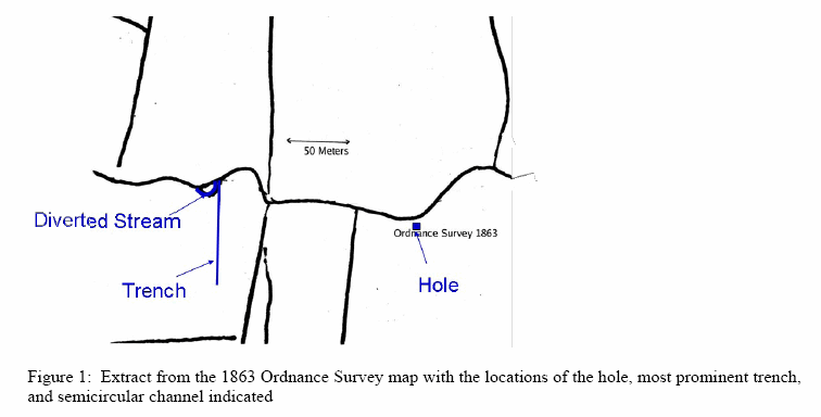
Figure 1: Extract from the 1863 Ordnance Survey map with the locations of the hole, most prominent trench, and semicircular channel indicated
-3-
The expeditions to the area described by Fitzgerald found four features that match his descriptions. The hole is
on the line between the crown of the ridge to the southwest and Church Hill to the northeast and is at the
boundary between Falabane on the north of the stream and Derrora on the south. From there, the ball lightning
went 200 m west to form the trench, then to “tear away” the stream bank to form the semicircular channel, and
finally across the stream to form the cave.
The electrical resistivity was measured at many places and in several seasons. It was 3x10³ to 6x10³ Ohms-cm.
The compressive yield strength was measured to be 530 +/- 120 kilo Newtons/m2. In estimating the minimum
force required to form the trenches, we will use 250 kilo Newtons/m2 as a reasonable lower limit.
With consideration that Fitzgerald reported key lengths in perches (5.08 m) with only one significant digit, we
found four features that are reasonably consistent with his report of the ball lightning excavations: the hole,
trench, semicircular channel, and cave. The hole and semicircular channel are quite consistent with the report
and are particularly unusual in the squareness and orientation of the hole and in the lack of that feature in the
Ordnance Survey map just five years before the event. Correlation of the trench and correlation of the cave with
Fitzgerald’s report are respectively complicated by the cultivation and division of the field and the presence of
the stream with its continual potential for undermining the bank of the stream.
Although the current morphology of the site is consistent with the report by Fitzgerald, consistency does not
constitute proof. The eyewitness recording by Fitzgerald is crucial. If we had seen the features described above
without knowing what he described, we would have plausibly ascribed them to the remains of a sink-hole (hole),
ridge and furrow cultivation (trench), an abandoned meander (semicircular channel) and undercutting of the
stream bank (cave). Knowing Fitzgerald’s report led to a more rigorous investigation. Probing the underwater
contour of the hole revealed the east end of a “20 ft square” hole that would be unusual. The semicircular
channel to the south of the stream as recorded in the OS map of 1863 was also revealed by a closer look.
Another alternative is that Fitzgerald labored to excavate the >100 tones of peat as a stunt to gain notoriety.
However, there was no report of the incident in the local paper in the three months following the date of the
event. The letter to the Royal Society was submitted in 1877, apparently stimulated by an observation of a
waterspout in the area. The event does not seem consistent with a stunt and there is no motive for deception.
From the Webmaster:
The second installment begins with comments by the investigators on their findings toward validation of Mr. Fitzgerald's century-old observations. Their discussion is expanded into giving a "differential diagnoses" of possible phenomena that could account for their physical findings describing the terrain of the countryside and the documented changes known to have occurred in area described by Fitzgerald shortly before and after the event that was the subject of his written report to the Royal Society.
Part of the Webmaster's original intent in publishing the complete article Extreme Ball Lightning, was to divide the article into three separate installments. The organization of the published article has been changed. The article has been separated into two installments - both of which have now been published on the Website. The VanDevender paper has now been published in its entirety beginning with the first installment and ending with the second.
Discussion
"We have no reason ........The surviving evidence ........ball lightning "
Second Installment for Extreme Ball Lightning